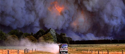
Bushfires now in Victoria and previously in Tasmania have had a devastating affect not only on forestry but also and more importantly livelihoods, livestock and lives with firefighters in Victoria currently building containment lines around fires burning east of Melbourne before “gusty and erratic” winds reach the area on Wednesday. Sources: The Guardian, Timberbiz
In Victoria at least nine buildings, including homes, were destroyed in two out of control bushfires at Bunyip and Yinnar South in West Gippsland on Sunday, and an emergency warning was issued for a third near Dargo in the high country in east Gippsland.
There were 19 fires burning out of control in eastern Victoria on Monday, scattered through the east Gippsland and highland areas.
Authorities have warned that more fires could start during thunderstorms forecast over the next three days. The Dargo fire started on Monday about 7km northwest of Dargo and travelled south, coming within 3km of the small town before heading past it and cutting off Dargo Road, which is the only route out of the high country. Residents were told to seek shelter because it was too late to leave.
Evacuation centres have been set up in Pakenham and Koo Wee Rup for residents affected by the fire which started in Bunyip state park on Friday and has burned through more than 12,000 hectares, towards the townships of Bunyip, Longwarry and Nar Nar Goon.
Warnings were downgraded to a watch and act following a slight cool change early Monday morning.
A spokesman from the state control centre said fire crews were concentrating on building containment lines along the eastern edge of the fire ahead of a forecast cold change on Wednesday, which is expected to bring gusty south-westerly winds and some dry lightning.
Other warnings were in place for a 17,000ha out of control fire at Licola, impacting communities around Mount Useful and the Avon River.
More than 2000 firefighters, supported by earthmoving equipment and aerial water bombers, were battling the fires on Monday.
Authorities said the Bunyip State Forest fire remained the priority because it was threatening the most number of homes. With more dry lightning expected as part of a forecast cool change over the next couple of days, the state control centre said it would have to juggle resources to prevent widespread property loss.
In Tasmania, the 2019 bushfires had a significant affect on the forest industry. Below is a description of the area of privately owned or managed forests affected by the fires as mapped by the Tasmanian Fire Service.
The Tasmanian Government has established a Bushfire Recovery Taskforce to oversee the medium and long term recovery from the current bushfires. The Taskforce can be contacted on 1800 567 567 or [email protected]
If your business has been impacted by the fires you can also call Business Tasmania on 1800 440 026 to register your details to keep informed of assistance provided by government.
Privately owned fire affected forests:
Areas affected by fire as mapped by TFS on 22 February and 28 February.
- Industrial hardwood plantation area burnt 2772ha
- Industrial softwood plantation area burnt 529ha
- Industrial estate burnt 4231ha
- Non industrial private forest estate burnt 30,847ha
- Non industrial hardwood plantation 399ha
Total private forest estate burnt 35,078 ha
Industrial estate refers to forests owned or managed by larger forest management companies.
Non-industrial private forest estate refers to forests not owned or managed by larger forest management companies but usually individuals or family scale entities.


