Advanced technology to map Victoria’s forests is being used as part of the State Government’s plans to modernise forest management, particularly for the Regional Forest Agreements. The Department of Environment, Land, Water and Planning (DEWLP) has acquired Victoria’s largest ever acquisition of Light Detection and Ranging (LiDAR) data across Victorian public forests. Source: Philip Hopkins for Timberbiz
LiDAR maps and monitors forests with ‘high conservation values’ – for example, what it calls ‘ecologically mature forests’ and rainforest, providing the foundation for long-term monitoring programs and management strategies.
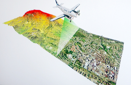
DEWLP in its Future of Our Forests newsletter for April said the existing RFAs were mapped 20 years ago using aerial photographs and information about forest growth.
“Mapping quality was variable and since that time there has been no comprehensive mapping of Victoria’s mature forests,” the newsletter said.
The department has now commissioned a comprehensive airborne LiDAR measurements program of Victoria’s forests in alliance with Melbourne University. The team leader of the program, Tom Hill, said from an aircraft, the LiDAR illuminated a target with a pulsed laser and measured the reflected pulses with a sensor.
“As the laser pulses penetrate the forest canopy to the understory, it provides a highly-detailed three-dimensional profile of the lower strata structure at a very high resolution (centimetre scale),” Mr Hill said.
“Data derived from LiDAR measurements, verified by on-the ground surveys, will allow us to create models that can be used to produce detailed, accurate forest maps.”
Focussing on public forests, it will identify areas with rainforests, cool temperate mixed forests, giant trees, multi-aged stands, areas with old-growth trees that have suffered recent disturbances, and old-growth stands, where the influence of past disturbances is now negligible.
DEWLP also set out its program aimed at acquiring better data on forest-dependent threatened species. A 2017 VEAC conservation report identified 84 forest-dependent threatened species.
The forest modernisation program, drawing on experts from the Arthur Rylah Institute and Melbourne University, includes landscape-scale surveys, habitat distribution models (HDMs), and population viability analysis.
The surveys aim to update knowledge on threatened species affected by timber harvesting, climate change, road construction and fire management.
Researchers will target 10 fauna species in eastern Victoria, including Leadbeater’s Possum, the Long-footed Potoroo, gliders and owls, Glossy Black Cockatoo, Large Brown Tree Frog and Giant Burrowing Frog. Surveys will also target 15 threatened aquatic species (galaxias and crayfish) and 27 threatened plants.
HDMs, which will be updated for 77 species, use information on where a species has been recorded and relate these data to environmental variables such as soil, prevailing climate, topography and remotely sensed spectral information.
“Researchers can then estimate suitability for a species across the landscape,” DEWLP said. HDM updates aim to improve understanding of the habitat suitability of the landscape for threatened forest-dependent species and predict the likelihood of suitable habitat in areas that have not been surveyed.
Population viability analysis will be used to predict the combined effects of timber harvesting, bushfire, planned burns, climate change and other forest disturbances on animal populations now and in the future.


