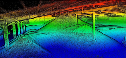
Interpine’s drone UAV team uses drone-based SLAM LiDAR technology that can work in GPS-denied environments to collect data and calculate product/material volumes for inventory stocktaking. Getting warehouse stockpile volumes in tight spaces and internal warehouses is now much easier. Source: Timberbiz
The LiDAR scanning technology also provides real-time autonomous control, allowing the drones to avoid and navigate around obstacles while operating in challenging and often dusty environments.
LiDAR can be used to create extremely detailed terrain and vegetation models.
This can be applied in planning, resource inventory erosion and biodiversity monitoring and environmental resource management.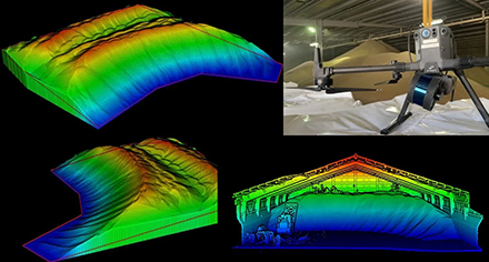
LiDAR assists the creation of GIS surfaces of trees and stand attributes and 3D walk through and visualisations.
Interpine has an expert team to arrange the collection of LIDAR requirements, tailoring the specification to suit the needs for analysis.
This can range from inside or under canopy surveys, to small aerial surveys using drone-based LiDAR systems, through to millions of hectares across multiple suppliers all being managed to deliver your project on time and to specification.
Interpine has developed a large toolbox to carry out a large number of LiDAR analysis workflows. These build on our expertise in LAStools, Quick Terrain Modeler, FUSION, Pix4D, R, Python, ERSI ArcPro and ArcMap Extensions and software tools.


