OneFortyOne has published an interactive ArcGIS Story Map that highlights the native conservation values the business protects within its Green Triangle plantation forests. Source: Timberbiz
OneFortyOne uses Geospatial Imagery Systems (GIS) to ensure that extensive, accurate, and reliable data is collected over time.
Story Maps are a great way to showcase data and how it is used to make informed decisions in the forest.
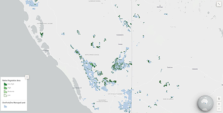
The Biodiversity within OneFortyOne’s Green Triangle Plantations ArcGIS Story Map takes viewers on an interactive journey through some of the native conservation areas across OneFortyOne’s South Australian and Victorian plantations.
“The data that is gathered by our business is incredibly valuable and can, when displayed using GIS mapping, provide a picture of activities over both space and time,” Ashwood Caesar, OneFortyOne Senior Geospatial Technologist says.
“We wanted to develop an interactive tool that showcases the native wildlife and plants living in our forests.”
The story is linked to a GIS map of the native conservation areas that fall within OneFortyOne estate across the Green Triangle Region. Each native conservation area is colour-coded in relation to its conservation rating.
“Using data, photography and audio we have been able to create a tour of some conservation areas within our forests,” John Cannon, OneFortyOne Senior GIS Analyst said.
“The audio and images help create an auditory and visual experience of what walking through OneFortyOne conservation areas can be like.”
“GIS is a tool that we use every day. If you’ve ever used Google Maps, then you’ve used GIS.”
For further information and to view the Story Map visit Sustainability Matters https://onefortyone.com/sustainability/sustainability-matters


