Imagine a remote forest, difficult to find, track down, let alone find data about. From the satellite straight to the comfort of your desk, you can now find some of the FSC forests around the globe on your computer screen, see how they are managed. Source: Timberbiz
FSC developed a map of certified forests – one of the three maps under the FSC on the Map initiative – so that it could visualise its certified areas. It gathers geospatial datasets which are attributed to a specific location, and describe features, characteristics, or objects on Earth’s surface.
The development of the Geographic Information System (GIS) Portal means that FSC can also combine this data with satellite imagery. This technology has the potential to transform how forest managers, certification bodies and auditors, independent researchers and any stakeholder evaluate the condition of the ecosystems, the loss and gain of forests, as well as the changes across the forest areas over time.
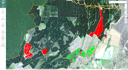
This is a view of a certified forest in New Zealand, displayed on the basis of data submitted to FSC on the Map and detects change across the forest area. Red means loss, and green means regeneration of forest areas.
FSC has asked certificate holders to contribute their forest data voluntarily and help build these maps. It has been delighted with the response as many certificate holders are stepping forward and the FSC believes this is a clear sign that the FSC on the Map initiative is welcomed and works. If you have not yet submitted your coordinates, you can still do so.
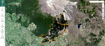
There are three separate maps, each with a specific function. The main portal is the FSC certified forest area map. It shows the geographical locations of FSC certified forests and their boundaries.
FSC on the Map has become a very useful tool for the FSC GIS Portal. You can now download the forest boundaries from the FSC on the Map onto the FSC GIS Portal, view a particular forest border and overlap it with information that you may be interested in, such as forest loss and gain (where certificate holders have managed to grow and restore forests), Indigenous Peoples lands, and protected lands.
This brings many added benefits for the certificate holders.
FSC GIS Portal uses satellite imagery to reveal any converted forest land. It provides the certification body with the undisputable evidence needed to confirm compliance of the forest manager with FSC standards and continued responsible management across their forest areas.
With the GIS technology, auditors can look at the map, zoom in to the forest boundaries provided by a certificate holder via the FSC on the Map, and overlap it with information available through credible, high-resolution, open-source data.
The FSC digital auditing process will become even more robust as this new technology will allow to see tree cover loss, intact forest landscapes, protected areas, indigenous and community lands, water courses, and the boundary data of certified forest area.
Certificate holders will be able to prove with relative ease that they have not converted their land since the last audit. Thanks to the GIS Portal technology, combined with FSC on the Map, it is much simpler to look at a ‘before’ and ‘after’ satellite image and the answer is right there.
Forest managers can show customers and stakeholders the location of their certified forests and how they are practising sustainable forest management practices today and over time. The information provided will also enable forest auditors to advise forest managers where to improve.
The technology can save time for the certification body and the certificate holders through the audit process. Currently, audits are carried out entirely on the forest site. However, as the audits can now be supported by the FSC GIS Portal and the insights it makes available, auditors will find it much easier to source specific data on the forest area and changes to the forest land over time. It will be more efficient and effective for both the auditors and the certificate holders to focus the visits to the forest site on these audit elements that cannot be currently assessed through the GIS technology, such as social and economic aspects of the given forest management.


