On 25-26 November the Forest Industry Engineering Association (FIEA) held its ForestTech conference in Melbourne, after a successful similar conference was held in New Zealand. Source: Timberbiz
The two-day program focused heavily on the use of LIDAR dedicating one whole day to the subject including workshops.
During the first day some time was spent on mobile computing and the tools to improve forest data collection as well as drones, UAVs and robotic advancements as they pertained to forest management.
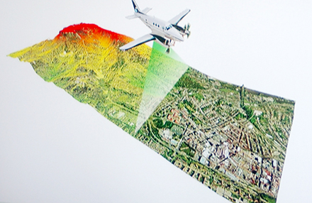
LIDAR stands for Light Detection and Ranging which is a remote sensing method using light in the form of pulsed laser beams to measure distances to earth. These pulses when combined with other data generate precise, three dimensional information about the shape of the earth and surface characteristics.
Aeroplanes and other flying objects such as UAVs (unmanned aerial vehicles), helicopters and drones are commonly used to gather the data.
Presentations by Swedish, Australian, Canadian and New Zealand experts filled the sessions that focused on advances in airborne and terrestrial LIDAR and how it was not being used successfully in forest operations.
After these the focus turned to two workshop sessions that delved deeper into LIDAR use. The first being on data generation and distribution while the second was on how to work with remotely sensed data.
After a 20 minute introductory session to kick off each workshop the floor was open to discussion and questions, which were varied and many times quite detailed.
Coverage of ForestTech will be in future issues Australasian Timber Magazine.


