Wellington, New Zealand technology start-up Lynker Analytics has been selected by the NZ Ministry for the Environment to lead a consortium including UAV Mapping NZ and Carbon Forest Services to inventory the extent of forest loss in New Zealand during 2017 and 2018. Source: Timberbiz
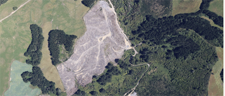
Each year 40,000 – 50,000 hectares of forest is harvested in New Zealand as part of normal forestry land use activity. Most of this forest area is replanted however, a small but significant area is deforested and converted to another land use.
Deforestation is an important form of land-use change from a greenhouse gas perspective. The Ministry assesses deforestation in New Zealand every two years to meet international reporting obligations under the United Nations Framework Convention on Climate Change and the Kyoto Protocol.
The Ministry also provides deforestation mapping to the Ministry for Primary Industries for use by their compliance teams monitoring deforestation under the New Zealand Emissions Trading Scheme.
Under this contract the consortium will field check over 7000 forested areas, covering approximately 84,000 hectares. These areas have already been identified in satellite imagery as having experienced forest disturbance during 2017 and 2018.
The primary objective is to determine what the current land use of each area is and therefore identify the areas of deforestation.
UAV Mapping NZ will manage the flying program which entails more than 200 flying hours across every district in the country. Multiple fixed wing Cesna 172 aircraft operated by Rotorua based Action Aviation will be used.
The images will then be input into a machine learning algorithm for land cover analysis.
“Our machine learning process will deliver a classification system that will firstly apportion land cover to sub-areas within each forest block,” Matt Lythe, Managing Director of Lynker Analytics said.
“This will generate detailed land cover information which we can then use to make final determinations of overall land use at a block level.
“The detail and consistency of the information from the modelling will make the final land cover class very data driven and defensible.”
Forestry expert on the team, Ollie Belton from Carbon Forest Services said that this approach will allow a more refined set of land-use classifications that aligns with both domestic and international rules on land-use, land-use change, and forestry.
“We will be able to accurately assess whether or not each block has been re-planted, is naturally re-generating, has suffered natural damage or has been converted to grazing or another purpose,” he said.
Scheduled for completion by 30 June this year the Consortium will also offset the aviation emissions associated with the project in accordance with the Ministry for the Environment’s Measuring and Reporting Greenhouse Gas Emissions using high quality New Zealand units from permanent forest sinks.


