Outsight is bringing the power of real-time LiDAR technology to the forestry industry with instantaneous forest mapping. Source: Timberbiz
The company is offering:
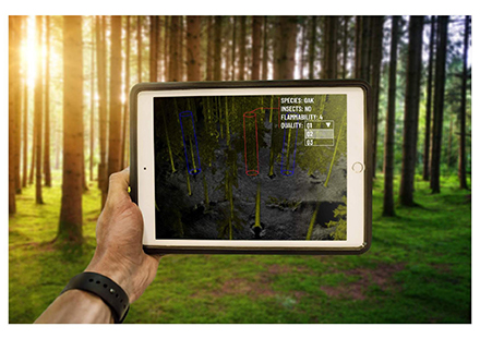
- An automated 3D solution that produces a 360° forest mapping in real time, and collects data on individual trees which operators can digitally tag
- Portable: the LiDAR box integrating Outsight’s software can be carried in a backpack and connected to a tablet for real-time surveys
- 3 to 5 times faster than usual data collecting methods while being accurate and exhaustive
- Offers GPS geolocation, allowing operators to overlap maps, if necessary.
Outsight, a leader in 3D Spatial Intelligence, has announced the launch of the first real-time LiDAR solution for the forestry industry.
Drawing on its established LiDAR expertise in other industries, Outsight has developed a mapping solution capable of generating a comprehensive 3D map of a forest in real-time. Taking no longer than the time needed for the human or machine operator to traverse the plot, Outsight’s solution automatically determines the exact position and characteristics of trees.
On-site operators can digitally tag each tree with supplemental information, including species or the presence of insects, that can be used for further analysis.
In July 2020, Outsight was selected from a large pool of candidates to be a recipient of the European Innovation Council’s inaugural Green Deal funding. A part of the European Union’s Green Deal Strategy, Outsight was chosen for its LiDAR-based environmental and forestry management and conservation solutions.
Outsight’s solution is already being used by forestry researchers around the world. Forestry professor, Philippe Nolet, has been using Outsight’s LiDAR processing technology to assist in his forest monitoring research at Université du Québec en Outaouais in Gatineau, Canada.
“With Outsight, we’re able to complete our surveys of the forest three times faster,” Mr Nolet said.
“Then, when we’re back in the office, we have a detailed inventory of the plot with all our notes automatically tagged to each tree, saving us a huge amount of time.”
The solution has also been adopted by Outsight’s Hong Kong-based partner, Insight Robotics, a leader in the Forestry Risk Management sector. Using Outsight’s ground-based LiDAR tool to supplement its market-leading aerial survey solution, Insight Robotics can provide its clients with even more accurate survey data, allowing customers to better manage their forests and plantations.
“Outsight’s LiDAR solution allows our team to quickly and accurately map a section of the forest and use the 3D map to complement our aerial survey results,” said William Tao.
Outsight has successfully designed and built the next generation of LiDAR processing solutions, which have been the subject of 73 patent applications.
Outsight’s innovative solutions have won numerous awards, including the prestigious Best of CES Innovation Award in Las Vegas and the Prism Award from world leaders in photonics and lasers.


