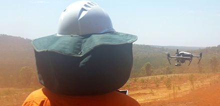
Trials of drone-assisted survival assessments of pine plantations are off to a flying start near Bunbury, Western Australia. Operations Officer Markus Streil said the current trials use small drones to take photos of re-established plantations and hundreds of images are then uploaded to a cloud service to create a range of models of the plantation. Source: Timberbiz
“The drone can capture photos of 90 hectares in 15 minutes, with those photos uploaded to the cloud to create orthomosaics, plant health layers and 3D models within hours,” Mr Streil said.
The specialised agriculture drone data processing provider can detect and count, with high accuracy, healthy eight-month-old seedlings, if images have a high resolution and don’t include many weeds.
“The challenges ahead are for the continued improvement of this technology so that we can get reliable survival counts for sites with more weeds and harvest debris,” Mr Streil said. “If we can get to a point where we are doing our survival assessments remotely via drone, it could save the FPC a lot of time and resources.”
The trials will be continuing with more imagery from Maringee plantation testing the algorithms, hopefully resulting in a smarter artificial intelligence seedling counting model for next year.
“Other potential benefits of remote sensing post-planting data include improved early growth monitoring and operational planning, implementation and evaluation,” Mr Streil said.


