There can be no doubt that Tasmania’s northwest is stunning part of the world. Full of wild coastlines, majestic rainforests and sweeping button grass plains.
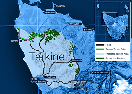
However, whilst there is no official recognition of the name “Tarkine” I think we all accept that name has stuck, and it is generally agreed that it stretches from the Arthur River in the north to the Pieman River in the south and is bound by the west coast and the Murchison Highway.
The Tarkine is an area of around 450,000 hectares, or as a commonly used measure for scale, 222,408 MCGs. Three quarters of that area is, rightly, already classified under conservation tenures.
The Tarkine is vast and diverse. Some is wild, windy coastline, some is beautiful button grass plains, some majestic rainforests, some shack communities and townships, some farms, some forestry and some of it mines. It is a beautiful area and anyone who has spent time exploring it will know there is a lot to see and a lot to take in.
The town of small mining town of Waratah is within the Tarkine area and the whole eastern border is flanked by the Murchison Highway. The town of Tullah sits in a juncture, so it is kind of half in the Tarkine and half out.
The Tarkine flanks the old mining towns of Roseberry and Corinna and includes the Sumac, Norfolk, Waratah, Rebecca, Pieman, Temma, Blackwater and Corinna Roads.
There are significant farmlands within this boundary, in particular in a place called Temma, originally a mining settlement. Savage River and other mines are also within the stated boundary as are the Reece and Bastyan hydro dams and power stations.
It is worth searching these places on Google Maps, then zoom out to get an understanding of the size of the area compared to these footprints.
In forestry terms less than 200 hectares is harvested per annum. A total of 0.05% of the Tarkine area and all from managed forests on the outskirts that border farm pastures.
Harvested forests in the area are regenerated, grown and nurtured to remain as productive forests for the future. Plantations are not established following harvesting in the area, just native regeneration. Much of the areas have been harvested multiple times over the generations and will be again. It is simply native tree farming, the difference between this type of farming and others of course is the length of the growing and harvesting cycle.
Some commentary would have you believe that the Tarkine is a dozen trees away from destruction, but that is simply not the case. The area known as the Tarkine is under no threat and all forestry and mining practices are strictly limited to agreed areas, areas that are miniscule in the scale of the vast protected areas.
I highly recommend a visit to this beautiful region, but if you don’t have time for a drive then please, take some time, do some research, and have a look at the area on some maps to understand the scale and diversity.
Whilst the boundary has been declared by the location of rivers and roads for convenience, the fact is there are areas both inside and outside of this boundary that have high conservation value. Equally there are areas inside and outside the boundary that provide for forestry, farming, recreational and mining resources.
The Tarkine and surrounding areas are a great example of how mining, forestry, recreation and conservation have coexisted in harmony for more than 150 years, well before it was nicknamed the Tarkine and well before the current protesters moved in and it will continue to be carefully and responsibly managed for generations to come.
Nick Steel is the CEO of the Tasmanian Forest Products Association.