
John O’Donnell
There are plenty of cases where bushfires travel very long distances in very short periods, including the Dunns Rd, Green Valley and Gospers Mtn bushfires in NSW in 2019/ 20 especially in hot dry conditions with high fuel loads. The areas of these bushfires were Dunns Rd, 334,000 ha, Green Valley, 208,000 ha and Gospers Mtn, 513,000 ha, they are all big fires, among many.
Evidence of the fast and vast bushfire spread is outlined in Figure 1 below for the Dunns Road bushfire, impacting into or close to impacting a number of towns at that stage, this is extracted from a Tumut and Adelong Times article. The Dunns Road fire was believed to have been started by a lightning strike on 28 December 2019 in a private pine plantation near Adelong and continued through January 2020. These image below is only an early stage of this fire.
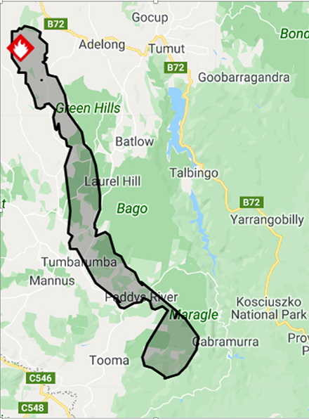 Figure 1. Dunns Road fire has grown to more than 54,000 hectares as at December 31, 2019, 4:11 pm. The Dunns Road fire now stretched from north west of Adelong, to down in the south past Cabramurra and Tooma, having burned more than 54,000 hectares. By Staff – December 31, 2019, 4:11 pm
The distance north to south is over 80 kilometres at this stage of the Dunns Rd bushfire. So, I believe that it is important to address cool hazard reduction burning across landscapes, not only immediately adjacent to towns, cities, infrastructure and assets.
In an article by Bill Gabbert January 10, 2020 in Wildfire “Six bushfires merge in Australia to burn 1.5 million acres”, the size of the Dunns Rd bushfire had increased to an estimated 316,754 hectares, burn small areas continued to burn, refer Figure 2 below. The other very large bushfire to the south of the Dunns Road bushfire is the Green Valley bushfire.
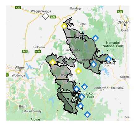 Figure 2. Dunns Road fire has grown to an estimated 316,754 hectares as of January 2020. The large fire to the south is the Green Valley fire.
Another very large bushfire in the area was the 1952 Mangoplah bushfire and the area of this fire is outlined in Figure 3. Unfortunately, I could only find poor quality mapping for this large bushfire, extracted from Harris et al, 2012. As outlined by Sullivan in 2004, this fire burnt from Mangoplah, north of Holbrook, NSW, to Corryong in north-eastern Victoria, a distance of 98 km, during two consecutive days of extreme fire danger. The fire commenced on the 22 January 1952 from fettlers burning-off on the Rock-Westby railway line near Mangoplah. The area burnt, mostly on 25 January 1952, was more than 330,000 ha, very similar in area to the Dunns Road bushfire. Some of the area of the Mangoplah bushfire overlapped the Green Valley bushfire, possibly a small area of the Dunns Rd bushfire.
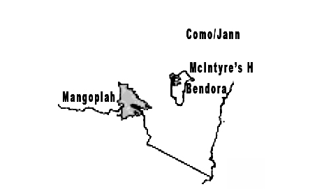 Figure 3. 1952 Mangoplah fire has grown to an estimated 330,000 hectares as of February 9, 1952.
The available NSW data confirms inadequate hazard reduction burning in general and across landscapes:
- the average annual fuel reduction burning in NSW between 2010 to 2019 was 153,291 hectares over 27 million hectares of forest in NSW. This equates to 0.57 % of forested areas hazard reduced per year and only 2.8 % over 5 years, extremely low rates.
- the fuel reduction burning areas in NSW between HRB in NSW in the years 1999-2003 were 355,507; 441,989; 436,369 and 432,630 hectares/ year, considerably higher than recent times.
- In 2019/ 20, the fuel reduction burning figure in NSW was 34,000 hectares, this equates to 0.13 % of forested areas hazard reduced by burning.
Fuel load levels are at high levels across large areas of forested lands, due to decline in/ low rates of fuel reduction burning in NSW over long periods. I consider that the current NSW approach focusses on a large number of listed threatened flora and fauna species and communities, reduced fire frequencies and inadequate assessment of the consequences of not cool burning. This policy environment reinforces the shift towards more widespread high intensity fire regimes in these same areas where cool fires are restricted.
Production of firebrands in the landscape is another important issue in regard to landscape hazard reduction management. As outlined in Ecos (CSIRO), 2017, Issue 227 Spotting the danger of long-distance firebrands, February 7, 2017 by Thea Williams, in the Black Saturday fires in February 2009 at Kilmore East, Victoria, spot fires were reported 30-40 kilometres downwind from the main fire front. Dr Andrew Sullivan’s team used the CSIRO Vertical Wind Tunnel to investigate just how strips of burning bark from these trees combust under the conditions of terminal velocity (the maximum speed at which an object travels through the air). From this they could deduce how far they could travel as viable firebrands. They tested flat, simple cylinders and curled cylinders of bark, oven-dried to mimic wildfire conditions. The tests showed that the average burnt out time for short tightly curled cylinders was more than 7 minutes. This suggests that a similar firebrand 2.7 m long would be capable of remaining alight for more than 30 minutes. Under conditions typical of a high intensity forest fire, the firebrand would be capable of travelling and causing a spot fire 37 km away. The research concluded that it is both the length and, importantly, also the way the strips curl in on themselves which make them so successful as long-distance firebrands.
Safe cool hazard reduction burning won’t stop bushfires in extreme conditions, but will assist in managing bushfires, reduce spotting and increase fire fighter safety in most instances.
Options that I see to potentially increase safe cool hazard reduction burning across the landscape include:
- Supporting cooperative community action and involvement such as currently occurring in the Kangaroo valley and other areas.
- Increasing training in forest bushfire management.
- Establishing processes like USA such as Fire Adapted Communities and Firewise USA.
- Greater Local Government involvement in bushfire management.
- Greater involvement of owners of key assets under threat from bushfires in bushfire management.
- Freely available information to the community of HRB burning areas each year and over time and fuel loads in the landscape.
- Increased utilisation of current RFS processes, forms, codes etc. Reporting broad area bushfire hazards to RFS using the form on the web.
Logically, cooperative regional and local approaches are the preferred approach to increase cool hazard reduction burning in the landscape. Opportunities for increasing cool hazard reduction burning were raised in my document “Potential ways we can increase annual cool hazard reduction burning area, effectiveness and safety in NSW?” dated 29 October 2020 on the VFFA website. Cooperative approaches are outlined in this document.
An article in Tenterfield Star “Tenterfield fires trigger demand for new management approach” dated 19 March 2019 highlighted community concerns/ efforts and the importance of the government and community working together to solve fuel build up issues. It would be beneficial for government, government agencies, local government, communities, contractors and applicable private sector to work through all potential opportunity areas to increase safe cool landscape hazard reduction burning across forested areas of NSW. The safety of NSW communities, infrastructure, forests, water quality, waterways, fauna, fish, air quality and heritage sites depend on this.
If we don’t adequately learn from the 2019/ 20 bushfires and earlier bushfires, increase cooperation and quickly adapt, more very large area, massive, intense and unsafe bushfires will occur again. It is best to avoid the massive impact across Australia, burning 5.2 million hectares in NSW alone and over 18 million hectares over Australia, with over 1 billion animal deaths in NSW and 3 billion nationally. There’s 22 million hectares of forested areas not burnt in 2019/ 20, much of this not hazard reduced for very long periods, combined with high fuel loads in much of the areas burnt in 2019/ 20.
John O’Donnell was a forester with the then NSW Forestry Commission for 11 years. He holds a Bachelor of Science (Forestry) Hons 1978 from Australian National University and a Post Graduate Diploma in Agronomy and Farming Systems from the University of Adelaide 1996 and 1997, majoring in environmental issues in agriculture. He was awarded a Commonwealth Forestry Scholarship in 1976 and 1977.


